Data archive
EUFAR Data Catalogue
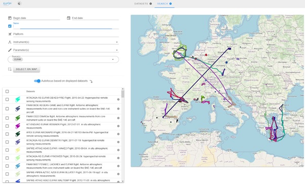
The new EUFAR Data Catalogue replaces the former EUFAR Flight Finder tool. The Catalogue is hosted by AERIS, the French Data and Services Cluster for Atmosphere. EUFAR Data Catalogue
This is a geospatial-temporal search interface to locate EUFAR data for download. The aim of the Catalogue is to facilitate the location and identification of EUFAR flights and to link to the appropriate data files in the archive. Users can search by geographical area on a map interface, by temporal constraints or using keywords or parameter names. Results are displayed on the map; clicking on a flight will show further details and links to the data.
EUFAR Data Archive
The EUFAR dataset combines data from flight campaigns and training courses funded under EUFAR FP7 project (2008-2013) and its successor EUFAR2 (2014-2018).
EUFAR's data archive activity seeks to improve access to and use of the data collected by instrumented aircraft in Europe, providing a unique portal to the data along with supporting metadata. This includes providing well-documented access to distributed archives and a secure accessible archive for remaining offline data. Support will be given to data providers to attain community-agreed standard data formats.
New data continue to be added to the EUFAR data and as of 2017, the archive currently provides links to 170 flights (including auxiliary data) for 55 EUFAR funded flight campaigns (~2TB) plus links to a further 9.3TB of ARSF and FAAM flights. Flight data from EUFAR supported research campaigns continue to arrive and be ingested as they become available.
Data Access
Most of EUFAR data is hosted by CEDA (for more information see the EUFAR dataset catalogue record at BADC) and all datasets are openly accessible.
Interoperability has been set up with other airborne data portals such as SAFIRE + the Data Portal of the French airborne research.
All users are required to acknowledge the data providers in any publication based on EUFAR data.
